Metro Vancouver Zoning Maps Available or in Progress through the project. This list will be updated regularly. Zoning data obtained from most recent municipal zoning ordinances for all Metro Vancouver municipalities. Multiple coders from our team review each zone, collecting information on key regulations influencing what can be built on the land and how it can be used. Key regulatory features include: uses allowed, floor space allowed (FSR where specified), maximum height, setbacks and footprint. We plan to make all data available along with a codebook in the months ahead. We welcome comments and corrections!
| MAP | LEVEL | DATE |
|---|---|---|
| Harmonized Use Category | Aggregate & Lot Level | August 2020 |
| FSR (Est. Floor Space to Lot Ratio) | Aggregate & Lot Level | In Progress |
| Residential Floor Space Allowed | Lot Level | In Progress |
| Number of Dwellings Allowed | Lot Level | In Progress |
| Number of Bedrooms Allowed | Lot Level | In Progress |
Municipal zoning isn’t the only regulatory context that matters for what can be built. We add the following layers to our maps reflecting broader restrictions and/or policy contexts that often work in conjunction with municipal zoning. The Agricultural Land Reserve (ALR), for instance, effectively works as provincial level zoning.
| LAYER | DESCRIPTION |
|---|---|
| ALR | Lands within the provincial Agricultural Land Reserve |
| Urban Centres | Lands identified by Metro Vancouver as an Urban Centre |
| First Nation Reserves | Lands under First Nations jurisdiction |
| Vancouver View Cones | Lands in the City of Vancouver with additional height limits for view cones |
| Vancouver Parks & School | Lands identified as municipal or regional parks or schools |
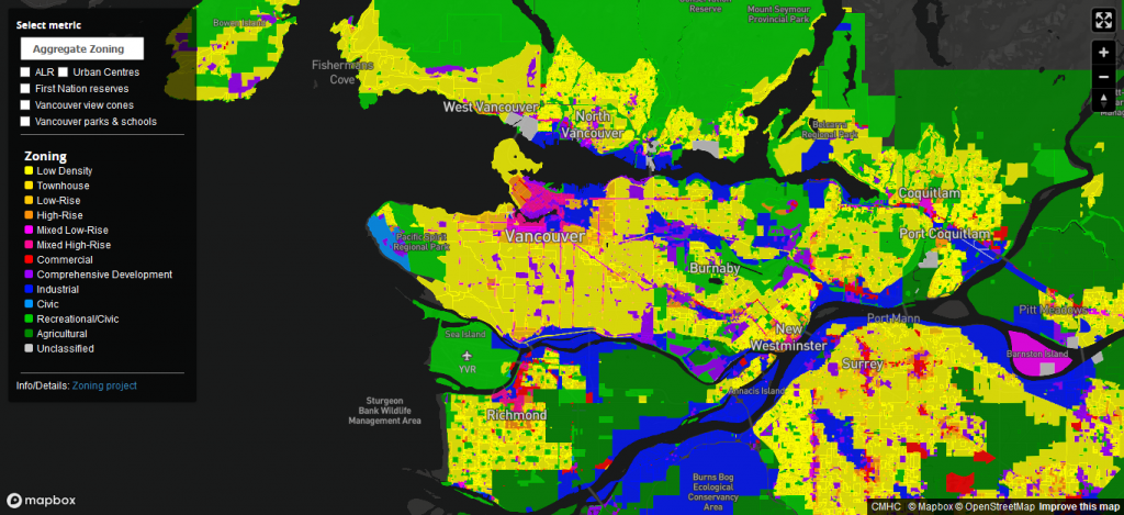
Each municipality has different regulations for what can be built and how land can be used. In our first map, we harmonize these regulations with respect to uses allowed. Primarily we harmonize residential zones by number of dwellings allowed and maximum heights, with separate simplified categories for non-residential zones. Of note: we currently group together low density zones containing a wide amount of internal variation with respect to everything from minimum lot sizes to the permissibility of duplexes, secondary suites and laneway houses.
| CATEGORY | DESCRIPTION |
|---|---|
| Low Density | Low Density Residential, including single and two family dwellings, with or without suites & laneways |
| Townhouse Residential | Residential including townhouse/rowhouse, triplexes, & four-plexes in addition to Low Density Residential |
| Low-Rise Residential | Residential including low-rise apartment buildings, Maximum height 12 m/40 ft, in addition to Townhouse Residential |
| High-Rise Residential | Residential including apartment buildings greater than 12 m/40 ft in addition to Low-Rise Residential |
| Mixed Low-Rise | Combines Residential with Commercial, maximum height 12 m/40 ft |
| Mixed High-Rise | Combines Residential with Commercial, greater than 12 m/40 ft in addition to Mixed Low-Rise |
| Commercial (Non-Residential) | Commercial Uses Only |
| Comprehensive Development | Lot “Spot Zoned” for Uses Specific to Site, May or May Not Include Residential |
| Industrial | Primary Industrial (rarely includes residential as live/work space or caretaker residence only) |
| Civic / Institutional | Insitutional Uses including Universities, Schools, Parks, Marinas, Cemeteries, Assembly Spaces, Hospitals, Care Centres, Community Services, etc. |
| Agricultural | Agricultural Use Only (includes aquaculture, livestock, forestry, fish & wildlife habitat, horse riding, bee keeping, kennel) |
| Unclassified | Not Otherwise Classified or Zoned |